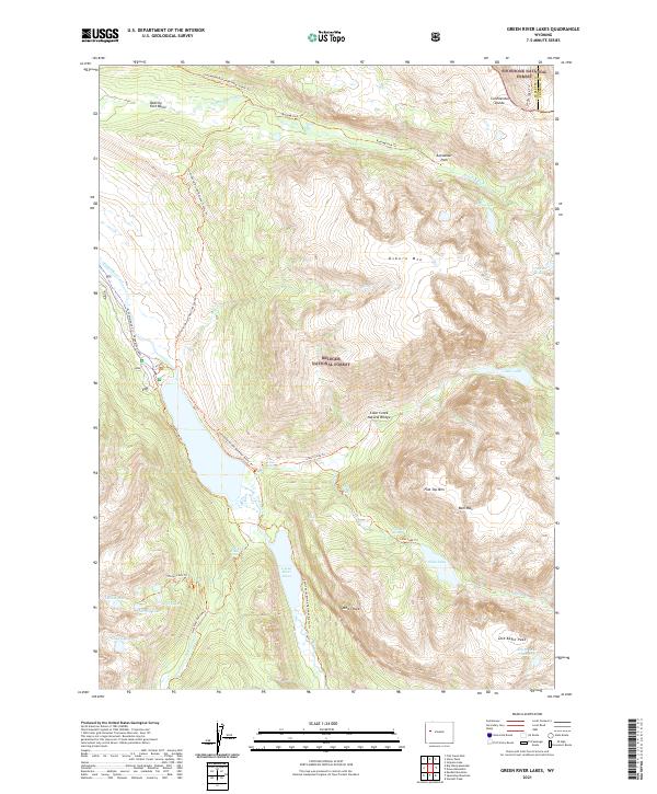
2021 Map of Green River Lakes
USGS Topo · Published 2021About this map
The Green River Lakes serve as a prominent gateway to the wilderness in this high-altitude Wyoming landscape. Situated along the boundary between the Shoshone National Forest and Bridger National Forest, the area is defined by massive glacial features and tectonic shifts. The Continental Divide National Scenic Trl traverses the region, providing access to landmarks like Clear Creek Natural Bridge and the steep slopes of Osborn Mtn.
Find a feature on this map
49 named features on this map. Tap any name to fly to it.
Don’t see what you’re looking for? This feature index may not catch every label — zoom into the map to look around manually.
Map Details
Editions of this 2021 Green River Lakes Map
This is the sole edition of this map. No revisions or reprints were ever made.
Other maps of this area

1909 · Fremont Peak
USGS Topo · 1:125,000

1955 · Thermopolis
USGS Topo · 1:250,000

1958 · Thermopolis
USGS Topo · 1:250,000

1962 · Thermopolis
USGS Topo · 1:250,000
1967 · Fish Creek Park
USGS Topo · 1:24,000
1968 · Union Peak
USGS Topo · 1:24,000
1968 · Simpson Lake
USGS Topo · 1:24,000
1968 · Gannett Peak
USGS Topo · 1:24,000
1968 · Downs Mountain
USGS Topo · 1:24,000
1968 · Squaretop Mountain
USGS Topo · 1:24,000