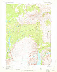
1968 Map of Simpson Lake
USGS Topo · Published 1972About this map
Shoshone National Forest defines this high-elevation landscape in Fremont County, where a complex network of pack trails served as the primary infrastructure in the late 1960s. The map illustrates a high alpine basin characterized by significant glacial features, with Simpson Lake and Ross Lake situated at the feet of massive landmarks like Windy Mountain and Shale Mountain. The drainage patterns of Jakeys Fork and Whiskey Creek dictate the movement of water and travelers through the area, with numerous smaller bodies of water such as Soapstone Lake, Dead Horse Lake, and Snowbank Lake scattered throughout the basins. For researchers, the presence of a Prospect near Lime Kiln Gulch and the named Salt Barrels Park offer clues to historical land use and early resource exploration in this section of the Wind River Range.
Find a feature on this map
44 named features on this map. Tap any name to fly to it.
Don’t see what you’re looking for? This feature index may not catch every label — zoom into the map to look around manually.
Map Details
Editions of this 1968 Simpson Lake Map
3 editions found
Other maps of this area

1905 · Younts Peak
USGS Topo · 1:125,000

1907 · Younts Peak
USGS Topo · 1:125,000

1909 · Fremont Peak
USGS Topo · 1:125,000

1955 · Thermopolis
USGS Topo · 1:250,000

1956 · Dubois
USGS Topo · 1:24,000

1956 · Warm Spring Mountain
USGS Topo · 1:24,000

1956 · Mason Draw
USGS Topo · 1:24,000

1958 · Thermopolis
USGS Topo · 1:250,000

1962 · Thermopolis
USGS Topo · 1:250,000
1968 · Union Peak
USGS Topo · 1:24,000