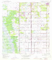
1945 Map of Greenacres City
USGS Topo · Published 1976About this map
Greenacres City stands at the northeastern edge of this mid-century Florida survey, representing a period of significant drainage and land management in Palm Beach County. The landscape is defined by an extensive grid of irrigation canals and a prominent levee system, illustrating the engineered transformation of former wetlands into habitable and agricultural land. A major transit artery, Floridas Turnpike (Toll Road), bisects the quadrangle, featuring the Lake Worth Interchange. This infrastructure facilitated the rapid post-war expansion of the region. Local industrial activity is evidenced by several borrow pits near the highway, while the north-south Range Line provides a foundational surveying reference for property and municipal development during this era of growth.
Find a feature on this map
6 named features on this map. Tap any name to fly to it.
Don’t see what you’re looking for? This feature index may not catch every label — zoom into the map to look around manually.
Map Details
Editions of this 1945 Greenacres City Map
4 editions found
Other maps of this area

1945 · Greenacres City
USGS Topo · 1:24,000

1945 · Lake Worth
USGS Topo · 1:24,000

1946 · Palm Beach Farms
USGS Topo · 1:24,000

1946 · Palm Beach
USGS Topo · 1:24,000

1947 · Delmar Farms
USGS Topo · 1:24,000

1949 · Lake Worth
USGS Topo · 1:24,000

1949 · Palm Beach Farms
USGS Topo · 1:24,000

1949 · Delmar Farms
USGS Topo · 1:24,000

1950 · Delray Beach
USGS Topo · 1:24,000

1950 · Greenacres City
USGS Topo · 1:24,000