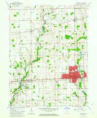
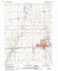
1962 Map of Greenfield
USGS Topo · Published 1977About this map
The Hancock County seat of Greenfield serves as the central hub for this early 1960s survey, showing a well-established grid surrounding the historic Courthouse and City Hall. To the west, small rural communities like Mohawk and Philadelphia are connected by the iconic National Road and the Pennsylvania Road, mirroring the transition from historic overland trails to modern highway travel. The landscape is defined by its agricultural layout, punctuated by numerous small family and community burial grounds including Griffith Cem, Alford Cem, and McNamee Cem.
Find a feature on this map
64 named features on this map. Tap any name to fly to it.
Don’t see what you’re looking for? This feature index may not catch every label — zoom into the map to look around manually.
Map Details
Editions of this 1962 Greenfield Map
5 editions found
Other maps of this area

1952 · Cumberland
USGS Topo · 1:24,000

1952 · Greenfield
USGS Topo · 1:24,000

1952 · Fountaintown
USGS Topo · 1:24,000

1952 · Ingalls
USGS Topo · 1:24,000

1952 · Mc Cordsville
USGS Topo · 1:24,000

1953 · Acton
USGS Topo · 1:24,000

1953 · Pendleton
USGS Topo · 1:24,000

1953 · Cincinnati
USGS Topo · 1:250,000

1956 · Cleveland
USGS Topo · 1:24,000

1956 · Morristown
USGS Topo · 1:24,000