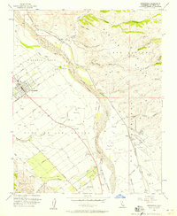
1956 Map of Greenfield
USGS Topo · Published 1957About this map
Agricultural development and historical Spanish land grants define this mid-1950s landscape in Monterey County. The Salinas River and Arroyo Seco provide the primary drainage for the valley floor, where a rigid grid of irrigation reservoirs and roads supports the region's farming economy. The Southern Pacific railroad corridor serves as the spine for smaller stations and settlements like Metz, Coburn, and Elsa. To the west, the community of Greenfield is established around Oak Park and the Greenfield Cemetery, while the eastern horizon is dominated by the foothills of the Gabilan Range. Numerous canyons, such as Lumber Canyon and Saucito Canyon, descend from these heights toward the river plain. The map documents complex property lines including the Posa de los Ositos Grant Bdy, reflecting the enduring influence of early California land tenure on the modern surveying of the area.
Find a feature on this map
36 named features on this map. Tap any name to fly to it.
Don’t see what you’re looking for? This feature index may not catch every label — zoom into the map to look around manually.
Map Details
Editions of this 1956 Greenfield Map
4 editions found
Other maps of this area

1912 · Metz
USGS Topo · 1:31,680

1915 · Soledad
USGS Topo · 1:62,500

1919 · King City
USGS Topo · 1:62,500

1919 · Junipero Serra
USGS Topo · 1:62,500

1921 · Metz
USGS Topo · 1:62,500

1939 · King City
USGS Topo · 1:62,500

1940 · Metz
USGS Topo · 1:62,500

1940 · Soledad
USGS Topo · 1:62,500

1941 · Junipero Serra
USGS Topo · 1:62,500

1947 · Metz
USGS Topo · 1:62,500