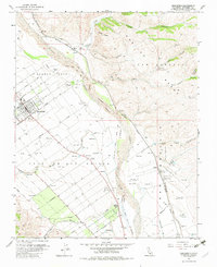
1956 Map of Greenfield
USGS Topo · Published 1982About this map
The Salinas River valley in the mid-1950s is defined by a grid of agricultural avenues and the path of the Southern Pacific railroad. The settlement of Greenfield appears as a developed core surrounded by orchards and fields, with the Greenfield Cemetery and Oak Park marking its northern edge. This area is historically significant for its large land grants, including the San Lorenzo (Sanchez) Grant and Posa de los Ositos Grant, which shaped the early development of Monterey County. The landscape transitions from the flat valley floor to the foothills of the Gabilan Range, where numerous canyons like Lumber Canyon and Saucito Canyon drain toward the river. Small rail-related stops and agricultural outposts such as Metz, Coburn, and Elsa trace the transportation corridor through the valley, while infrastructure like the Los Ositos Substation and King City North Base indicate the era's technical expansion.
Find a feature on this map
48 named features on this map. Tap any name to fly to it.
Don’t see what you’re looking for? This feature index may not catch every label — zoom into the map to look around manually.
Map Details
Editions of this 1956 Greenfield Map
4 editions found
Other maps of this area

1912 · Metz
USGS Topo · 1:31,680

1915 · Soledad
USGS Topo · 1:62,500

1919 · King City
USGS Topo · 1:62,500

1919 · Junipero Serra
USGS Topo · 1:62,500

1921 · Metz
USGS Topo · 1:62,500

1939 · King City
USGS Topo · 1:62,500

1940 · Metz
USGS Topo · 1:62,500

1940 · Soledad
USGS Topo · 1:62,500

1941 · Junipero Serra
USGS Topo · 1:62,500

1947 · Metz
USGS Topo · 1:62,500