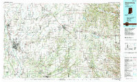
1986 Map of Greensburg
USGS Topo · Published 1989About this map
The Jefferson Proving Ground dominates the southern landscape of this 1986 survey, marking a significant military presence amidst the agricultural heartland of southeastern Indiana. The map captures the regional hubs of Greensburg and Columbus, connected by a network of historic transit lines including the Baltimore & Ohio RR and Penn Central RR. This era of documentation shows the intricate drainage patterns of the Flatrock River and Laughery Creek, which defined early settlement boundaries across Decatur and Ripley counties.
Find a feature on this map
238 named features on this map. Tap any name to fly to it.
Don’t see what you’re looking for? This feature index may not catch every label — zoom into the map to look around manually.
Map Details
Editions of this 1986 Greensburg Map
2 editions found
Other maps of this area

1915 · Lawrenceburg
USGS Topo · 1:48,000

1915 · College Corner
USGS Topo · 1:48,000

1915 · Harrison
USGS Topo · 1:48,000

1918 · College Corner
USGS Topo · 1:62,500

1928 · Lawrenceburg
USGS Topo · 1:62,500

1932 · Lawrenceburg
USGS Topo · 1:62,500

1942 · Franklin
USGS Topo · 1:125,000

1942 · Columbus
USGS Topo · 1:125,000

1943 · Aberdeen
USGS Topo · 1:24,000

1943 · Aurora
USGS Topo · 1:24,000