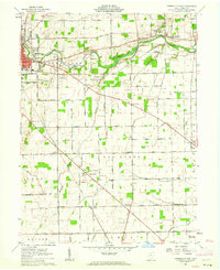
1961 Map of Greenville East
USGS Topo · Published 1962About this map
Greenville Creek meanders through the heart of Darke County, anchoring a landscape defined by its agricultural roots and early industrial sites in the early 1960s. The map illustrates the town of Greenville as it expands eastward, with the Pennsylvania and Baltimore and Ohio railroads carving paths through the countryside. Notable historic landmarks include Bears Mill along the creek and the Lansdowne Landing Strip, which speak to the area's transition from 19th-century milling to mid-century aviation.
Find a feature on this map
64 named features on this map. Tap any name to fly to it.
Don’t see what you’re looking for? This feature index may not catch every label — zoom into the map to look around manually.
Map Details
Editions of this 1961 Greenville East Map
3 editions found
Other maps of this area

1905 · Brookville
USGS Topo · 1:62,500

1911 · Covington
USGS Topo · 1:62,500

1944 · Covington
USGS Topo · 1:62,500

1953 · Cincinnati
USGS Topo · 1:250,000

1953 · Muncie
USGS Topo · 1:250,000

1956 · Muncie
USGS Topo · 1:250,000

1957 · Cincinnati
USGS Topo · 1:250,000

1960 · New Madison
USGS Topo · 1:24,000

1961 · Laura
USGS Topo · 1:24,000

1961 · Dawn
USGS Topo · 1:24,000