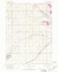
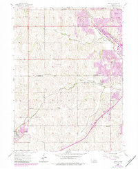
1956 Map of Gretna
USGS Topo · Published 1970About this map
Gretna and the neighboring settlements of Millard and Chalco anchor this mid-century look at the Sarpy and Douglas County line. The landscape is defined by the diverging paths of the Chicago Burlington and Quincy and the Union Pacific railroads, which serviced the agricultural and industrial corridors between South Papillion Creek and West Papillion Creek. Local genealogy and land use patterns are well-documented through a dense network of one-room schoolhouses, including Sunny Slope Sch, Lone Hill Sch, and Iron Bluff Sch, alongside community burial grounds such as Pennsylvania Cem and Mt Auburn Cem. Revisions from 1969 appear in purple, highlighting the emerging urban extension near Millard, where a Trailer Park and Drag Strip signal the encroaching modern infrastructure into the traditional farmsteads of Richland and Forest City townships.
Find a feature on this map
26 named features on this map. Tap any name to fly to it.
Don’t see what you’re looking for? This feature index may not catch every label — zoom into the map to look around manually.
Map Details
Editions of this 1956 Gretna Map
6 editions found
Other maps of this area

1893 · Fremont
USGS Topo · 1:125,000

1896 · Fremont
USGS Topo · 1:125,000

1955 · Fremont
USGS Topo · 1:250,000

1956 · Gretna
USGS Topo · 1:24,000

1956 · Cedar Creek
USGS Topo · 1:24,000

1956 · Ralston
USGS Topo · 1:24,000

1956 · Springfield
USGS Topo · 1:24,000

1956 · Irvington
USGS Topo · 1:24,000

1957 · Fremont
USGS Topo · 1:250,000

1958 · Fremont
USGS Topo · 1:250,000