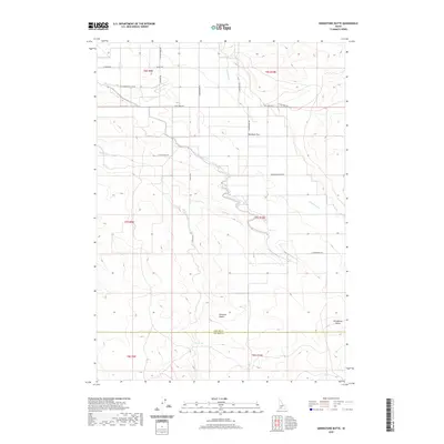
2020 Map of Grindstone Butte
USGS Topo · Published 2020About this map
Grindstone Butte stands as a prominent landmark in this arid portion of the Bruneau Desert, where the landscape is defined by its drainages and isolated water sources. The map traces the boundary between Elmore and Owyhee counties, cutting through a region where life and travel are dictated by the presence of Dove Spring and the seasonal flows of Sailor Creek and Deadman Cr. The road network, including family-named routes like W Stimpson Cellar Rd and S Rosevear Rd, suggests a history of ranching and remote settlement typical of Idaho's high desert. This 2020 survey provides a detailed look at the modern topography of Deadman Flat, documenting the continued importance of these named tracks across the sagebrush-covered terrain.
Find a feature on this map
26 named features on this map. Tap any name to fly to it.
Don’t see what you’re looking for? This feature index may not catch every label — zoom into the map to look around manually.
Map Details
Editions of this 2020 Grindstone Butte Map
This is the sole edition of this map. No revisions or reprints were ever made.
Other maps of this area

1947 · Hammett
USGS Topo · 1:24,000

1947 · Glenns Ferry
USGS Topo · 1:24,000

1947 · Pasadena Valley
USGS Topo · 1:24,000

1948 · Pasadena Valley
USGS Topo · 1:24,000

1948 · Hammett
USGS Topo · 1:24,000

1948 · Glenns Ferry
USGS Topo · 1:24,000

1948 · Twentymile Butte
USGS Topo · 1:24,000

1948 · Glenns Ferry
USGS Topo · 1:62,500

1948 · Grindstone Butte
USGS Topo · 1:24,000
1949 · Pot Hole Canyon
USGS Topo · 1:24,000