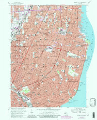
1968 Map of Grosse Pointe
USGS Topo · Published 1984About this map
The suburban expansion of eastern Wayne and Macomb Counties is captured here in the late 1960s, a period of massive residential growth defined by the construction of the Edsel Ford Freeway. The shoreline of Lake St Clair anchors the affluent communities of Grosse Pointe Farms, Grosse Pointe Park, and Grosse Pointe Shores, where the Sacred Heart Academy and various private clubs overlook the water. Inland, the map reveals a dense network of mid-century neighborhoods served by an extensive system of parochial and public schools, including Roseville High Sch and St Joan of Arc Sch. Significant infrastructure of the era is evident at the Detroit City Airport and the Eastland Shopping Center, which transformed local commerce. The presence of Mt Calvary Cem and the Grand Trunk Western RR provide historical continuity amidst the rapidly modernizing landscape of Roseville and Warren.
Find a feature on this map
136 named features on this map. Tap any name to fly to it.
Don’t see what you’re looking for? This feature index may not catch every label — zoom into the map to look around manually.
Map Details
Editions of this 1968 Grosse Pointe Map
4 editions found
Other maps of this area

1905 · Detroit
USGS Topo · 1:62,500

1905 · Grosse Pointe
USGS Topo · 1:62,500

1908 · Rochester
USGS Topo · 1:62,500

1912 · Mt Clemens
USGS Topo · 1:62,500

1918 · Detroit
USGS Topo · 1:62,500

1918 · Grosse Pointe
USGS Topo · 1:62,500

1924 · Detroit
USGS Topo · 1:62,500

1929 · Mt Clemens
USGS Topo · 1:62,500

1934 · Detroit
USGS Topo · 1:62,500

1936 · Warren
USGS Topo · 1:31,680