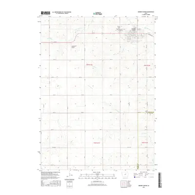
2015 Map of Grundy Center
USGS Topo · Published 2015About this map
Grundy Center stands as the central hub of this prairie landscape, where a dense network of lettered and numbered avenues and streets reflects the organized growth of the Iowa interior. This 2015 survey reveals a community deeply rooted in its local history, evidenced by the clustering of significant sites such as Rosehill Cem and Grundy Center Cem near the town's northern edge. The surrounding terrain is defined by the subtle drainage patterns of Black Hawk Cr and Minnehaha Cr, which wind through the agricultural sections and past the Grundy Center Municipal Airport. To the south, the map documents the boundary where Grundy Co Tama Co meet, marking a transition between these two fertile counties. For researchers, the map provides precise locations for outlying landmarks like Palermo Township Cem and Lincoln Township Cem, offering a clear view of the area's rural cemetery distribution and township structure.
Find a feature on this map
60 named features on this map. Tap any name to fly to it.
Don’t see what you’re looking for? This feature index may not catch every label — zoom into the map to look around manually.
Map Details
Editions of this 2015 Grundy Center Map
This is the sole edition of this map. No revisions or reprints were ever made.
Other maps of this area
1954 · Waterloo
USGS Topo · 1:250,000
1955 · Waterloo
USGS Topo · 1:250,000
1960 · Marshalltown
USGS Topo · 1:62,500
1960 · Conrad West
USGS Topo · 1:24,000
1960 · Conrad East
USGS Topo · 1:24,000
1971 · Dike
USGS Topo · 1:24,000
1971 · Lincoln
USGS Topo · 1:24,000
1971 · Gladbrook
USGS Topo · 1:24,000
1979 · Grundy Center
USGS Topo · 1:24,000
1979 · Holland
USGS Topo · 1:24,000