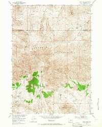
1952 Map of Guffy Peak
USGS Topo · Published 1966About this map
Copper Mountain dominates this high-altitude landscape along the border of Hot Springs and Fremont counties. Surveyed in the early 1950s, the map documents a transition from cattle ranching to specialized mineral extraction in the Wyoming interior. Named peaks like Guffy Peak overlook a network of isolated homesteads, including the Meeks Ranch and Quien Sabe Ranch, alongside sites marked as outmoded such as Guffy Ranch. The terrain is deeply etched by seasonal watercourses like Antelope Creek, Kirby Creek, and Dry Creek, which define the drainage patterns of Bridger Basin. Of particular interest to industrial historians is the clustering of tungsten and copper prospects, specifically the McGraw Copper Mine, Stardust Tungsten Mine, and Comet Tungsten Mine. These labels suggest a period of post-war exploration for strategic materials in the high desert of the Missouri River Basin development area.
Find a feature on this map
27 named features on this map. Tap any name to fly to it.
Don’t see what you’re looking for? This feature index may not catch every label — zoom into the map to look around manually.
Map Details
Editions of this 1952 Guffy Peak Map
4 editions found
Other maps of this area

1951 · Birdseye Pass
USGS Topo · 1:24,000

1951 · Bonneville
USGS Topo · 1:24,000

1952 · Gates Butte
USGS Topo · 1:24,000

1952 · Rathbun Ranch
USGS Topo · 1:24,000

1952 · Picard Ranch
USGS Topo · 1:24,000

1952 · De Pass
USGS Topo · 1:24,000

1952 · Guffy Peak
USGS Topo · 1:24,000

1955 · Thermopolis
USGS Topo · 1:250,000

1955 · Arminto
USGS Topo · 1:250,000

1957 · Rathbun Ranch
USGS Topo · 1:24,000