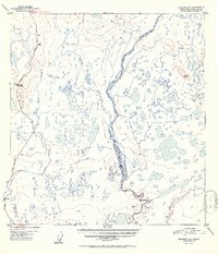
1952 Map of Gulkana C-3
USGS Topo · Published 1952About this map
The Gakona River flows through a landscape defined by an intricate network of lakes and glacial outwash plains in this 1952 study. The western edge of the quadrangle is anchored by the Richardson Highway, a vital corridor for territorial transportation connecting interior Alaska to the coast. Along this route, the presence of the Haggard Road Camp and the settlement of Sourdough highlights the infrastructure required to maintain passage through the Copper River Basin during the mid-century era. The terrain is marked by the prominence of Hogan Hill and numerous watercourses like Sourdough Creek and Tulsona Creek, which feed into the braided channels of the larger river systems. This map captures the region's hydrography and topography just as aerial photogrammetry was refining the precision of northern mapping, documenting the intersection of the Copper River drainage with the early highway system.
Find a feature on this map
15 named features on this map. Tap any name to fly to it.
Don’t see what you’re looking for? This feature index may not catch every label — zoom into the map to look around manually.
Map Details
Editions of this 1952 Gulkana C-3 Map
2 editions found
Other maps of this area

1949 · Gulkana C-2
USGS Topo · 1:63,360

1949 · Gulkana D-3
USGS Topo · 1:63,360

1949 · Gulkana B-2
USGS Topo · 1:63,360

1950 · Gulkana D-4
USGS Topo · 1:63,360

1950 · Gulkana B-3
USGS Topo · 1:63,360

1950 · Gulkana C-3
USGS Topo · 1:63,360

1950 · Gulkana C-4
USGS Topo · 1:63,360

1951 · Gulkana
USGS Topo · 1:250,000

1951 · Gulkana B-4
USGS Topo · 1:63,360

1952 · Gulkana D-3
USGS Topo · 1:63,360