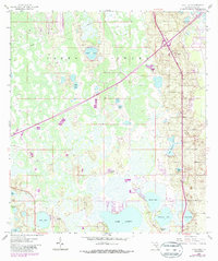
1959 Map of Gum Lake
USGS Topo · Published 1987About this map
The northern reaches of Haines City and the expanding residential footprint of Holiday Manor anchor this Florida landscape during the mid-to-late 20th century. The map reveals a delicate balance between settlement and the immense Green Swamp, which dominates the northern and western portions of the quadrangle. This area is defined by its complex hydrology, featuring numerous isolated basins such as Grass Lake, Sand Lake, and Tangerine Lake.
Find a feature on this map
22 named features on this map. Tap any name to fly to it.
Don’t see what you’re looking for? This feature index may not catch every label — zoom into the map to look around manually.
Map Details
Editions of this 1959 Gum Lake Map
5 editions found
Other maps of this area

1944 · Polk City
USGS Topo · 1:31,680

1944 · Auburndale
USGS Topo · 1:31,680

1953 · Dundee
USGS Topo · 1:24,000

1953 · Intercession City
USGS Topo · 1:24,000

1953 · Davenport
USGS Topo · 1:24,000

1955 · Orlando
USGS Topo · 1:250,000

1957 · Orlando
USGS Topo · 1:250,000

1958 · Orlando
USGS Topo · 1:250,000

1959 · Gum Lake
USGS Topo · 1:24,000

1959 · Lake Louisa SW
USGS Topo · 1:24,000