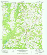
1973 Map of Gum Springs
USGS Topo · Published 1977About this map
Industrial and rural landscapes converge across this East Texas territory, where a sprawling Oil Field dominates the central terrain north of Big Springs. The 1970s landscape is defined by a dense network of energy infrastructure, including numerous Oil Wells, gas wells, and pumping stations interspersed among the rolling timber and creek bottoms. The human history of the area is preserved in a significant collection of family-named burial grounds and local congregations, such as the Boatwright Cem and Sardis Ch near Pleasant Grove. Drainage for the region is provided by the winding Bowles Creek and Johnson Creek, while larger water bodies like Graham Lake and Ashby Lake offer distinct landmarks. Small communities like Stringtown and Good Springs serve as anchors for the rural road network, which connects scattered residences and roadside facilities such as the Roadside Park near the southern county line.
Find a feature on this map
43 named features on this map. Tap any name to fly to it.
Don’t see what you’re looking for? This feature index may not catch every label — zoom into the map to look around manually.
Map Details
Editions of this 1973 Gum Springs Map
This is the sole edition of this map. No revisions or reprints were ever made.
Other maps of this area

1935 · Henderson
USGS Topo · 1:48,000

1937 · Troupe
USGS Topo · 1:48,000

1939 · Henderson
USGS Topo · 1:62,500

1943 · Troup
USGS Topo · 1:62,500

1943 · Cushing
USGS Topo · 1:62,500

1943 · Rusk
USGS Topo · 1:62,500

1945 · Cushing
USGS Topo · 1:62,500

1945 · Rusk
USGS Topo · 1:62,500

1953 · Palestine
USGS Topo · 1:250,000

1956 · Tyler
USGS Topo · 1:250,000