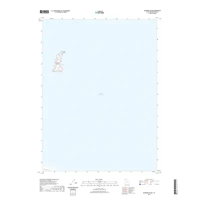
2020 Map of Gunnison Island
USGS Topo · Published 2020About this map
Gunnison Island and its smaller neighbor Cub Island rise from the northwest waters of the Great Salt Lake in this 2020 study of Box Elder County. The terrain of the larger island is defined by a series of distinct indentations and coves, including Pelican Bay, Lambourne Bay, and Seagull Bay. Located in a secluded reach of the lake, these landmasses represent an isolated environment where the land meets high-salinity waters at Phantom Bay and South Bay. This modern topographic record captures the exact shoreline and contour elevations of these remote islands, providing a precise baseline for understanding the fluctuating levels of the surrounding desert sea.
Find a feature on this map
8 named features on this map. Tap any name to fly to it.
Don’t see what you’re looking for? This feature index may not catch every label — zoom into the map to look around manually.
Map Details
Editions of this 2020 Gunnison Island Map
This is the sole edition of this map. No revisions or reprints were ever made.
Other maps of this area

1954 · Brigham City
USGS Topo · 1:250,000

1958 · Brigham City
USGS Topo · 1:250,000

1962 · Brigham City
USGS Topo · 1:250,000

1968 · Rozel Point
USGS Topo · 1:24,000

1969 · Rozel Point SW
USGS Topo · 1:24,000

1969 · Gunnison Island SW
USGS Topo · 1:24,000

1969 · Carrington Island NW
USGS Topo · 1:24,000

1969 · Strongs Knob
USGS Topo · 1:24,000

1969 · Gunnison Island
USGS Topo · 1:24,000
1969 · Gunnison Island NE
USGS Topo · 1:24,000