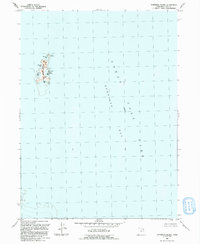
1991 Map of Gunnison Island
USGS Topo · Published 1991About this map
Gunnison Island State Wildlife Management Area dominates the western portion of this survey, protecting a critical sanctuary within the hypersaline waters of Great Salt Lake. This isolated landmass, along with the smaller Cub Island, provides a specialized habitat for migratory birds, as evidenced by the series of inlets named for local fauna and early explorers. The map details the intricate shoreline of the island, including Phantom Bay, Pelican Bay, and Seagull Bay to the west, and Lambourne Bay to the east. Located within the larger Gunnison Bay, the area is defined by the 4200-foot elevation mark, illustrating the fluctuating shoreline characteristic of this high-desert lake system in the early 1990s.
Find a feature on this map
11 named features on this map. Tap any name to fly to it.
Don’t see what you’re looking for? This feature index may not catch every label — zoom into the map to look around manually.
Map Details
Editions of this 1991 Gunnison Island Map
This is the sole edition of this map. No revisions or reprints were ever made.
Other maps of this area

1954 · Brigham City
USGS Topo · 1:250,000

1958 · Brigham City
USGS Topo · 1:250,000

1962 · Brigham City
USGS Topo · 1:250,000

1968 · Rozel Point
USGS Topo · 1:24,000

1969 · Rozel Point SW
USGS Topo · 1:24,000

1969 · Gunnison Island SW
USGS Topo · 1:24,000

1969 · Carrington Island NW
USGS Topo · 1:24,000

1969 · Strongs Knob
USGS Topo · 1:24,000

1969 · Gunnison Island
USGS Topo · 1:24,000
1969 · Gunnison Island NE
USGS Topo · 1:24,000