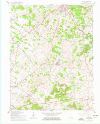
1961 Map of Guston
USGS Topo · Published 1977About this map
Ekron and Guston anchor this portion of Meade County, where the Louisville and Nashville railroad cuts a diagonal path through the karst-pocked landscape. The region is defined by a dense network of country roads connecting small rural settlements and agricultural hubs. In the north, Brandenburg and its hilltop neighbor Eastwood Hills overlook the terrain near the County Fairground. The map documents a community deeply rooted in its local institutions, evidenced by numerous rural churches like New Highland Ch and Salem Ch. Of particular interest to researchers is the presence of an Oil Well and multiple pipelines crossing the south, indicating the mid-century industrial footprint alongside traditional farming. From the cluster at Brandenburg Station to the outlying homes in Hillgrove, the map captures the transition of this Kentucky countryside as it appeared following the 1961 culture revision.
Find a feature on this map
29 named features on this map. Tap any name to fly to it.
Don’t see what you’re looking for? This feature index may not catch every label — zoom into the map to look around manually.
Map Details
Editions of this 1961 Guston Map
2 editions found
Other maps of this area

1928 · Hardinsburg
USGS Topo · 1:48,000

1931 · Hardinsburg
USGS Topo · 1:62,500

1931 · Corydon
USGS Topo · 1:62,500

1941 · Ekron
USGS Topo · 1:62,500

1946 · Rock Haven
USGS Topo · 1:24,000

1947 · Irvington
USGS Topo · 1:24,000

1947 · Garfield
USGS Topo · 1:24,000

1947 · Mauckport
USGS Topo · 1:24,000

1947 · Hardinsburg
USGS Topo · 1:62,500

1947 · Ekron
USGS Topo · 1:62,500