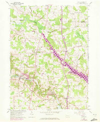
1960 Map of Hadley
USGS Topo · Published 1972About this map
Sandy Lake and its surrounding wetlands form a central corridor through this western Pennsylvania landscape, which includes portions of both Crawford and Mercer counties. The settlement pattern reflects a mid-20th-century transition, with established communities like Sheakleyville and Hadley connected by a network of rural roads and the Penn Central rail line. The landscape is dotted with generational landmarks essential for genealogical research, such as the Peterson Cem, Caldwell Cem, and Maple Grove Cem.
Find a feature on this map
45 named features on this map. Tap any name to fly to it.
Don’t see what you’re looking for? This feature index may not catch every label — zoom into the map to look around manually.
Map Details
Editions of this 1960 Hadley Map
3 editions found
Other maps of this area

1906 · Linesville
USGS Topo · 1:62,500

1908 · Shenango
USGS Topo · 1:62,500

1908 · Linesville
USGS Topo · 1:62,500

1911 · Stoneboro
USGS Topo · 1:62,500

1913 · Stoneboro
USGS Topo · 1:62,500

1923 · Meadville
USGS Topo · 1:62,500

1925 · Meadville
USGS Topo · 1:62,500

1943 · Meadville
USGS Topo · 1:62,500

1943 · Stoneboro
USGS Topo · 1:62,500

1950 · Cleveland
USGS Topo · 1:250,000
Featured Places
- New Vernon Township, PA
- Sheakleyville, PA
- Schofield Corners, New Vernon Township
- Sandy Creek Township, PA
- Greenwood Township, PA