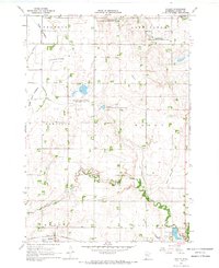
1967 Map of Hadley
USGS Topo · Published 1969About this map
Hadley and the surrounding township lands of Skandia and Lowville are defined by a singular hydrological transformation where once-vast lakes have been reclaimed as productive agricultural basins. The landscape is dominated by these former water bodies, including the massive Great Oasis Lakebed, Crooked Lakebed, and Rush Lakebed, which are now crisscrossed by drainage systems like Judicial Ditch No 14. These lakebeds represent a significant shift in the local geography of Murray County, transitioning from open water to tillable land and conservation tracts.
Find a feature on this map
28 named features on this map. Tap any name to fly to it.
Don’t see what you’re looking for? This feature index may not catch every label — zoom into the map to look around manually.
Map Details
Editions of this 1967 Hadley Map
3 editions found
Other maps of this area

1953 · New Ulm
USGS Topo · 1:250,000

1954 · Fairmont
USGS Topo · 1:250,000

1957 · New Ulm
USGS Topo · 1:250,000

1958 · New Ulm
USGS Topo · 1:250,000

1958 · Fairmont
USGS Topo · 1:250,000

1967 · New Ulm
USGS Topo · 1:250,000

1967 · Balaton
USGS Topo · 1:24,000

1967 · Slayton
USGS Topo · 1:24,000
1967 · Balaton SW
USGS Topo · 1:24,000

1967 · Hadley
USGS Topo · 1:24,000