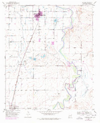
1951 Map of Hagerman
USGS Topo · Published 1978About this map
Hagerman and Lake Arthur anchor this Pecos Valley landscape, revealing an intricate network of desert irrigation and rail-dependent agriculture in the mid-20th century. The Atchison Topeka and Santa Fe railroad serves as the primary spine of the region, connecting local agricultural infrastructure like the Stock Pens and Buffalo Valley Farm to wider markets. Water management is the defining characteristic of the terrain, visible through the meandering Pecos River and its tributaries like Rio Felix. A patchwork of ditches and reservoirs, including Lake Tolliver, Prichard Lake, and Buffalo Lake, sustain the valley floor, while numerous scattered Windmill sites indicate the reliance on groundwater for both livestock and homesteads. The inclusion of a Landing Strip and the Ball Park in Hagerman reflects the community development and modernization occurring between the original 1951 survey and subsequent photorevisions.
Find a feature on this map
17 named features on this map. Tap any name to fly to it.
Don’t see what you’re looking for? This feature index may not catch every label — zoom into the map to look around manually.
Map Details
Editions of this 1951 Hagerman Map
2 editions found
Other maps of this area

1950 · Dexter West
USGS Topo · 1:24,000

1950 · Dexter East
USGS Topo · 1:24,000

1951 · Ninemile Well
USGS Topo · 1:24,000

1951 · Diamond Mound
USGS Topo · 1:24,000

1951 · Hagerman
USGS Topo · 1:24,000

1952 · Bar C Bar Ranch
USGS Topo · 1:24,000

1952 · Hagerman SW
USGS Topo · 1:24,000

1953 · Espuela
USGS Topo · 1:24,000

1954 · Carlsbad
USGS Topo · 1:250,000

1955 · Artesia NE
USGS Topo · 1:24,000