
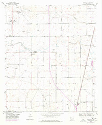
1953 Map of Espuela
USGS Topo · Published 1954About this map
The high plains of the Pecos River Valley south of the Chaves Co and Eddy Co line reveal a landscape transitioning from agricultural dependence to industrial and military utility. Water management is central to the area's development, evidenced by the Cottonwood Artesian Recorder Well and several irrigation features including Cottonwood Creek and a network of abandoned ditches. Social life in this rural corridor is anchored by the Cottonwood Community Church and the nearby Cottonwood School, while the eastern edge is defined by the Atchison Topeka and Santa Fe railroad line passing through Espuela. The map also records the remnants of World War II-era aviation infrastructure at the Walker Air Base Emergency Landing Field (Aband), alongside active extraction sites like the active caliche pit.
Find a feature on this map
22 named features on this map. Tap any name to fly to it.
Don’t see what you’re looking for? This feature index may not catch every label — zoom into the map to look around manually.
Map Details
Editions of this 1953 Espuela Map
2 editions found
Other maps of this area

1951 · Hagerman
USGS Topo · 1:24,000

1952 · Hagerman SW
USGS Topo · 1:24,000

1954 · Carlsbad
USGS Topo · 1:250,000

1955 · Artesia
USGS Topo · 1:24,000

1955 · Artesia NE
USGS Topo · 1:24,000

1955 · Spring Lake
USGS Topo · 1:24,000

1955 · Hackberry Ranch
USGS Topo · 1:24,000

1955 · Hope NE
USGS Topo · 1:24,000

1955 · Roswell
USGS Topo · 1:250,000

1956 · Hope SE
USGS Topo · 1:24,000