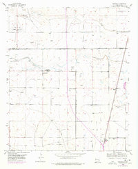
1953 Map of Espuela
USGS Topo · Published 1978About this map
Agricultural development and water management define this landscape on the border of Chaves and Eddy counties. The presence of the Cotton Compress and several specialized wells, such as the Cottonwood Artesian Recorder Well, highlight the area's reliance on irrigation and the cotton industry. Local life centers around the Cottonwood School and Cottonwood Community Church, providing a clear look at the social fabric of this rural community in the mid-20th century.
Find a feature on this map
17 named features on this map. Tap any name to fly to it.
Don’t see what you’re looking for? This feature index may not catch every label — zoom into the map to look around manually.
Map Details
Editions of this 1953 Espuela Map
2 editions found
Other maps of this area

1951 · Hagerman
USGS Topo · 1:24,000

1952 · Hagerman SW
USGS Topo · 1:24,000

1953 · Espuela
USGS Topo · 1:24,000

1954 · Carlsbad
USGS Topo · 1:250,000

1955 · Artesia
USGS Topo · 1:24,000

1955 · Artesia NE
USGS Topo · 1:24,000

1955 · Spring Lake
USGS Topo · 1:24,000

1955 · Hackberry Ranch
USGS Topo · 1:24,000

1955 · Hope NE
USGS Topo · 1:24,000

1955 · Roswell
USGS Topo · 1:250,000