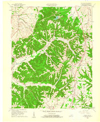
1961 Map of Halls Gap
USGS Topo · Published 1961About this map
The Green River and the South Fork Green River carve a complex drainage pattern through this section of Lincoln County, defining the early 1960s landscape. This era shows a rural economy transitioning through timber and tobacco, with small, tightly knit settlements like Turnersville and Highland anchored by community institutions. Educational and religious centers are prominent, including Memorial High Sch and Highland Sch, alongside numerous country churches such as Pleasant Point Ch and South Fork Ch.
Find a feature on this map
42 named features on this map. Tap any name to fly to it.
Don’t see what you’re looking for? This feature index may not catch every label — zoom into the map to look around manually.
Map Details
Editions of this 1961 Halls Gap Map
2 editions found
Other maps of this area

1905 · Harrodsburg
USGS Topo · 1:125,000

1952 · Halls Gap
USGS Topo · 1:24,000

1952 · Eubank
USGS Topo · 1:24,000

1952 · Crab Orchard
USGS Topo · 1:24,000

1952 · Hustonville
USGS Topo · 1:24,000

1952 · Lancaster
USGS Topo · 1:24,000

1952 · Yosemite
USGS Topo · 1:24,000

1952 · Stanford
USGS Topo · 1:24,000

1952 · Junction City
USGS Topo · 1:24,000

1952 · Woodstock
USGS Topo · 1:24,000