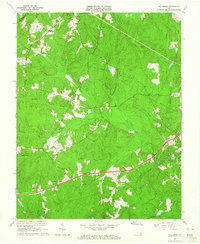
1963 Map of Hallsboro
USGS Topo · Published 1965About this map
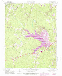
Swift Creek and its many tributaries, including Tomahawk Creek and Nuttree Creek, define the drainage patterns of this central Virginia landscape during the early 1960s. The settlement at Hallsboro sits near the northern boundary, while Winterpock and Otterdale anchor the southern and central sections of the quadrangle. This period shows a rural environment punctuated by community institutions such as Mt Hermon Ch, Chesterfield Ch, and Brown Grove Ch, alongside family-named landmarks like Lester Cem and Tomahawk Cem. A notable recreational feature, the Southside Speedway, is located on the eastern edge of the survey area. The topography reveals the complex network of "branches" and "creeks" like Reedy Branch and Horsepen Creek that dictated early road placements and farm boundaries before the extensive suburban expansion of later decades.
Find a feature on this map
25 named features on this map. Tap any name to fly to it.
Don’t see what you’re looking for? This feature index may not catch every label — zoom into the map to look around manually.
Map Details
Editions of this 1963 Hallsboro Map
5 editions found
Other maps of this area

1890 · Goochland
USGS Topo · 1:125,000

1892 · Goochland
USGS Topo · 1:125,000

1897 · Amelia
USGS Topo · 1:125,000

1936 · Richmond West
USGS Topo · 1:24,000

1942 · Westhampton
USGS Topo · 1:31,680

1943 · Fine Creek Mills
USGS Topo · 1:31,680

1943 · Chesterfield
USGS Topo · 1:31,680

1943 · Goodes Bridge
USGS Topo · 1:31,680

1943 · Hallsboro
USGS Topo · 1:31,680

1943 · Beach
USGS Topo · 1:24,000