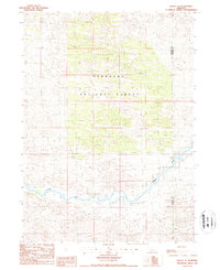
1986 Map of Halsey SE
USGS Topo · Published 1987About this map
The Nebraska National Forest dominates this section of the Sandhills, where hand-planted woodlands meet the meandering course of the Dismal River. This mid-1980s provisional survey shows a landscape defined by its transition from the forested sections in the north to the river-cut valley below. The boundary between Thomas Co and Blaine Co bisects the eastern portion of the map, illustrating the sparse administrative divisions of this high plains region. Much of the terrain is navigated only by 4wd tracks that thread between the dunes, emphasizing the isolation of this part of the forest. The proximity of the river to the wooded hills suggests a unique local ecology where the water table supports both the expansive timber stands and the riparian valley floor.
Find a feature on this map
4 named features on this map. Tap any name to fly to it.
Don’t see what you’re looking for? This feature index may not catch every label — zoom into the map to look around manually.
Map Details
Editions of this 1986 Halsey SE Map
This is the sole edition of this map. No revisions or reprints were ever made.
Other maps of this area

1948 · Linscott
USGS Topo · 1:62,500

1948 · Halsey
USGS Topo · 1:62,500

1950 · Linscott
USGS Topo · 1:62,500

1950 · Halsey
USGS Topo · 1:62,500

1951 · Dunning
USGS Topo · 1:62,500

1951 · Hoagland
USGS Topo · 1:62,500

1954 · North Platte
USGS Topo · 1:250,000

1956 · North Platte
USGS Topo · 1:250,000

1957 · North Platte
USGS Topo · 1:250,000

1967 · North Platte
USGS Topo · 1:250,000