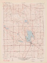
1948 Map of Hamilton
USGS Topo · Published 1948About this map
Hamilton Lake dominates this landscape of northeastern Indiana, serving as the focal point for the village of Hamilton and surrounding recreation spots like Forest Park Beach and Cold Springs. Surveyed in the late 1930s, the map reveals a post-war rural landscape where established farming townships like Otsego and Steuben are dotted with small landmarks of local genealogy. Community life is anchored by family-named plots and rural institutions, including Teagarden Cem, Otsego Center Ch, and South Scott Ch.
Find a feature on this map
48 named features on this map. Tap any name to fly to it.
Don’t see what you’re looking for? This feature index may not catch every label — zoom into the map to look around manually.
Map Details
Editions of this 1948 Hamilton Map
2 editions found
Other maps of this area

1939 · Hamilton
USGS Topo · 1:24,000

1939 · Angola East
USGS Topo · 1:24,000

1939 · Clear Lake
USGS Topo · 1:24,000

1940 · Metz
USGS Topo · 1:24,000

1940 · Clear Lake
USGS Topo · 1:24,000

1941 · Angola West
USGS Topo · 1:24,000

1942 · Ashley
USGS Topo · 1:24,000

1942 · Angola West
USGS Topo · 1:24,000

1947 · Angola East
USGS Topo · 1:24,000

1948 · Hamilton
USGS Topo · 1:24,000