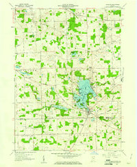
1959 Map of Hamilton
USGS Topo · Published 1961About this map
The glacial waters of Hamilton Lake dominate the central landscape of this Steuben County corner, where the community of Hamilton serves as the focal point for regional lake life and commerce. The map records a dense network of lakeside developments including Circle Park, Oakwood Shores, and Clarks Landing, reflecting the mid-century evolution of the shoreline from seasonal retreat to established settlement. A distinctive rural infrastructure is visible in the agricultural hinterlands, marked by family-named landmarks like the Donald Kunkle Ditch and numerous rural burial grounds such as Teegardin Cem and North Otsego Cem. Transport and utility networks slice through the township boundaries, from the path of the Wabash railroad to a prominent modern Pipeline. This 1959 revision provides a clear record of the intersection between the natural hydrology of Pigeon Creek and the man-made improvements of the era, including the Hamilton Sch and the local Microwave Station.
Find a feature on this map
54 named features on this map. Tap any name to fly to it.
Don’t see what you’re looking for? This feature index may not catch every label — zoom into the map to look around manually.
Map Details
Editions of this 1959 Hamilton Map
2 editions found
Other maps of this area

1939 · Hamilton
USGS Topo · 1:24,000

1939 · Angola East
USGS Topo · 1:24,000

1939 · Clear Lake
USGS Topo · 1:24,000

1940 · Metz
USGS Topo · 1:24,000

1940 · Clear Lake
USGS Topo · 1:24,000

1941 · Angola West
USGS Topo · 1:24,000

1942 · Ashley
USGS Topo · 1:24,000

1942 · Angola West
USGS Topo · 1:24,000

1947 · Angola East
USGS Topo · 1:24,000

1948 · Hamilton
USGS Topo · 1:24,000