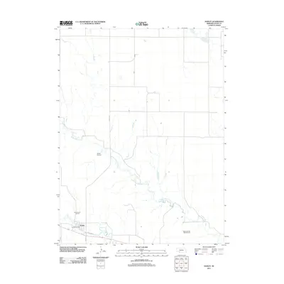
2011 Map of Hamlet
USGS Topo · Published 2011About this map
Hamlet sits at the confluence of the high plains and the winding valleys of Southwest Nebraska, where the waters of Stinking Water Creek and Frenchman Creek meet. This 2011 survey captures the village and its surrounding agricultural landscape in Hayes County, anchored by local institutions like the Hamlet Post Office and the Meadow Lawn Cemetery. The map documents the rural infrastructure of the early 21st century, from the primary thoroughfare of Old US Hwy 6 to the specialized Malone M-bar Ranch Airport. The topography is defined by the incision of Corral Canyon into the surrounding tableland, illustrating the drainage patterns that have dictated settlement and ranching boundaries for generations. Researchers can trace the modern road network, including Hamlet Rd and Dr 357, as they navigate the section lines of this sparsely populated ranching country.
Find a feature on this map
10 named features on this map. Tap any name to fly to it.
Don’t see what you’re looking for? This feature index may not catch every label — zoom into the map to look around manually.
Map Details
Editions of this 2011 Hamlet Map
This is the sole edition of this map. No revisions or reprints were ever made.
Other maps of this area

1954 · McCook
USGS Topo · 1:250,000

1957 · McCook
USGS Topo · 1:250,000

1958 · McCook
USGS Topo · 1:250,000

1973 · Palisade
USGS Topo · 1:24,000

1973 · Palisade SW
USGS Topo · 1:24,000

1973 · Wauneta SE
USGS Topo · 1:24,000

1974 · Hamlet
USGS Topo · 1:24,000

1974 · Dittons Creek SE
USGS Topo · 1:24,000

1974 · Hayes Center
USGS Topo · 1:24,000
1974 · Palisade NE
USGS Topo · 1:24,000