
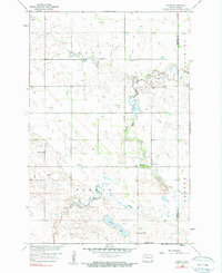
1958 Map of Hamlin
USGS Topo · Published 1960About this map
The Wild Rice River winds through the prairies of southeastern North Dakota in this late 1950s survey, showing a landscape defined by isolated farmsteads and rural townships like Hall and Herman. This area, mapped for the development of the Missouri River Basin, centers on the small settlement of Hamlin, which is supported by local infrastructure including a nearby Landing Field.
Find a feature on this map
15 named features on this map. Tap any name to fly to it.
Don’t see what you’re looking for? This feature index may not catch every label — zoom into the map to look around manually.
Map Details
Editions of this 1958 Hamlin Map
2 editions found
Other maps of this area

1907 · Wyndmere
USGS Topo · 1:125,000

1953 · Fargo
USGS Topo · 1:250,000

1956 · Fargo
USGS Topo · 1:250,000

1958 · Cayuga NW
USGS Topo · 1:24,000

1958 · Geneseo
USGS Topo · 1:24,000
1958 · Cayuga
USGS Topo · 1:24,000

1960 · Wyndmere
USGS Topo · 1:24,000

1960 · De Lamere
USGS Topo · 1:24,000

1960 · Milnor
USGS Topo · 1:24,000

1964 · Kreiser Lake
USGS Topo · 1:24,000