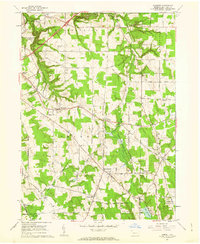
1960 Map of Hammett
USGS Topo · Published 1962About this map
Wintergreen Gorge and its namesake Wintergreen Gorge Cemetery define the northwestern corner of this landscape in Erie County, where the sprawling Behrend Campus Pa State University meets the steep relief of Sixmile Creek. The map shows a region of dense small-scale settlements and crossroads in the early 1960s, including Hammett, West Greene, and Phillipsville. A distinct rural-industrial pattern is evident in the straight lines of the Pipeline cutting diagonally across the terrain, contrasting with the leisure culture found at the Kuhl Road Speedway and the natural basin of Lake Pleasant. Genealogists will find significant value in the documentation of numerous local landmarks such as St Boniface Sch & Ch, Mt Calvary Cem, and rural gathering points like Bogus Corners and Weeds Corners.
Find a feature on this map
54 named features on this map. Tap any name to fly to it.
Don’t see what you’re looking for? This feature index may not catch every label — zoom into the map to look around manually.
Map Details
Editions of this 1960 Hammett Map
3 editions found
Other maps of this area

1899 · Erie
USGS Topo · 1:62,500

1900 · Erie
USGS Topo · 1:62,500

1913 · North East
USGS Topo · 1:62,500

1915 · North East
USGS Topo · 1:62,500

1923 · Cambridge Springs
USGS Topo · 1:62,500

1925 · Cambridge Springs
USGS Topo · 1:62,500

1929 · Union City
USGS Topo · 1:62,500

1932 · Union City
USGS Topo · 1:62,500

1943 · North East
USGS Topo · 1:62,500

1943 · Cambridge Springs
USGS Topo · 1:62,500