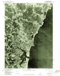
1977 Map of Hampton
USGS Topo · Published 1981About this map
The salt marshes and tidal estuaries of Rockingham County dominate this late-1970s orthophoto, showing the complex interaction between the New Hampshire coastline and the Atlantic. The Taylor River and Hampton River meander through dense wetlands, creating a distinct natural barrier between the inland settlements and the developed shoreline. The layout of Hampton Beach and Seabrook Beach is clearly visible, illustrating the concentrated coastal development of the era. To the north, Cable Road serves the more residential stretches near North Beach. This aerial perspective, produced in cooperation with the Soil Conservation Service, provides a clear view of the drainage patterns and land use in Hampton and Seabrook during a period of steady growth along the New Hampshire seacoast.
Find a feature on this map
14 named features on this map. Tap any name to fly to it.
Don’t see what you’re looking for? This feature index may not catch every label — zoom into the map to look around manually.
Map Details
Editions of this 1977 Hampton Map
This is the sole edition of this map. No revisions or reprints were ever made.
Other maps of this area

1888 · Newburyport
USGS Topo · 1:62,500

1890 · Newburyport
USGS Topo · 1:62,500

1893 · Dover
USGS Topo · 1:62,500

1893 · York
USGS Topo · 1:62,500

1894 · Newburyport
USGS Topo · 1:62,500

1916 · Dover
USGS Topo · 1:62,500

1918 · Dover
USGS Topo · 1:62,500

1920 · York
USGS Topo · 1:62,500

1932 · Newburyport
USGS Topo · 1:48,000

1934 · Exeter
USGS Topo · 1:62,500