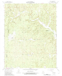
1968 Map of Handy
USGS Topo · Published 1983About this map
Handy serves as a central point in this part of the Mark Twain National Forest, where the landscape is defined by an intricate network of hollows and karst features. The presence of Spout Spring Cave and several upland ponds like Cupola Pond and McFarland Pond reflects the unique hydrology of the Ozark Plateau. A mix of religious and communal life is anchored by Handy Ch and the Bristol Cem, while the nomenclature of the land—ranging from Stillhouse Hollow to Tram Hollow—hints at earlier eras of local production and timber transport. To the east, Big Burren Ch sits near the headwaters of Big Burren Creek, marking the sparse but persistent settlement pattern within the forest boundaries during the late 1960s.
Find a feature on this map
45 named features on this map. Tap any name to fly to it.
Don’t see what you’re looking for? This feature index may not catch every label — zoom into the map to look around manually.
Map Details
Editions of this 1968 Handy Map
3 editions found
Other maps of this area

1939 · Doniphan
USGS Topo · 1:62,500

1941 · Gatewood
USGS Topo · 1:62,500

1944 · Van Buren
USGS Topo · 1:62,500

1944 · Grandin
USGS Topo · 1:62,500

1945 · Doniphan
USGS Topo · 1:62,500

1945 · Gatewood
USGS Topo · 1:62,500

1946 · Grandin
USGS Topo · 1:62,500

1946 · Van Buren
USGS Topo · 1:62,500

1957 · Poplar Bluff
USGS Topo · 1:250,000

1959 · Poplar Bluff
USGS Topo · 1:250,000