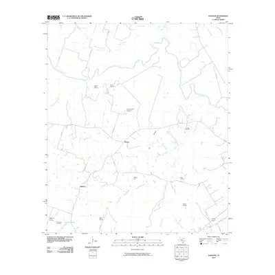
2010 Map of Hanover
USGS Topo · Published 2010About this map
The Little River meanders across this rural Milam County landscape, shaping a terrain defined by subtle rises and creek-carved hollows. Centered on the small community of Hanover, the area is networked by farm-to-market roads and county routes that connect isolated ranchlands and family-named landforms like Wilson Hill and Cox Hollow. The settlement pattern is deeply tied to the land's drainage systems, with various branches such as Yellow Rabbit Branch and Alligator Creek feeding into the main river channel.
Find a feature on this map
39 named features on this map. Tap any name to fly to it.
Don’t see what you’re looking for? This feature index may not catch every label — zoom into the map to look around manually.
Map Details
Editions of this 2010 Hanover Map
This is the sole edition of this map. No revisions or reprints were ever made.
Other maps of this area

1954 · Austin
USGS Topo · 1:250,000

1956 · Caldwell
USGS Topo · 1:62,500

1956 · Milano
USGS Topo · 1:62,500

1961 · Hanover
USGS Topo · 1:24,000

1961 · Cameron
USGS Topo · 1:24,000

1961 · Rockdale East
USGS Topo · 1:24,000

1962 · Goodwill
USGS Topo · 1:24,000

1962 · Calvert
USGS Topo · 1:24,000

1962 · Maysfield
USGS Topo · 1:24,000
1962 · Ben Arnold
USGS Topo · 1:24,000