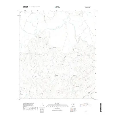
2019 Map of Hanover
USGS Topo · Published 2019About this map
Hanover serves as the central point of this Milam County landscape, where the terrain is defined by the winding course of the Little River and a dense network of creek drainages. For genealogists and local historians, this survey is particularly notable for the high density of small family and community burial grounds that dot the countryside, including the Oxsheer-Smith Cem, the curiously named Hanged Man's Cem, and the Coxes Providence Community Cem. The map illustrates a predominantly rural, agricultural structure where connectivity relies on farm-to-market roads like FM 2095 and named local routes such as 22 Hills Rd. Water sources are abundant throughout the quadrangle, with Beaver Springs and numerous branches like Yellow Rabbit Br and Alligator Cr cutting through prominent elevation features like Wilson Hill and the distinctive Eland Rough.
Find a feature on this map
45 named features on this map. Tap any name to fly to it.
Don’t see what you’re looking for? This feature index may not catch every label — zoom into the map to look around manually.
Map Details
Editions of this 2019 Hanover Map
This is the sole edition of this map. No revisions or reprints were ever made.
Other maps of this area

1954 · Austin
USGS Topo · 1:250,000

1956 · Caldwell
USGS Topo · 1:62,500

1956 · Milano
USGS Topo · 1:62,500

1961 · Hanover
USGS Topo · 1:24,000

1961 · Cameron
USGS Topo · 1:24,000

1961 · Rockdale East
USGS Topo · 1:24,000

1962 · Goodwill
USGS Topo · 1:24,000

1962 · Calvert
USGS Topo · 1:24,000

1962 · Maysfield
USGS Topo · 1:24,000
1962 · Ben Arnold
USGS Topo · 1:24,000