
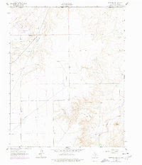
1962 Map of Hansford Camp
USGS Topo · Published 1965About this map
The Hitchland Gas and Oil Field defines the industrial character of this High Plains landscape along the border of Texas and Oklahoma in the early 1960s. This survey records a workspace of modern extraction, where a vast network of pipelines and gas wells crisscross the terrain. Amidst this energy infrastructure, the remnants of local community life persist at the New Hope Sch and New Hope Cem, situated near the small settlement of Hansford Camp. The topography is shaped by the dramatic breaks of Hackberry Creek and the winding course of Palo Duro Creek in the southeast corner. Significant landmarks like Mount Holland and Lightning Point provide orientation above the creek beds, while an Athletic Field near the camp suggests the social pulse of this mid-century petroleum outpost.
Find a feature on this map
19 named features on this map. Tap any name to fly to it.
Don’t see what you’re looking for? This feature index may not catch every label — zoom into the map to look around manually.
Map Details
Editions of this 1962 Hansford Camp Map
2 editions found
Other maps of this area

1954 · Perryton
USGS Topo · 1:250,000

1958 · Perryton
USGS Topo · 1:250,000

1962 · Kimball
USGS Topo · 1:24,000

1962 · Waka SW
USGS Topo · 1:24,000

1968 · Hardesty
USGS Topo · 1:24,000

1968 · Hardesty SE
USGS Topo · 1:24,000

1968 · Guymon SE
USGS Topo · 1:24,000

1973 · Horseshoe Hill
USGS Topo · 1:24,000

1973 · Waka
USGS Topo · 1:24,000

1974 · Bernstein
USGS Topo · 1:24,000