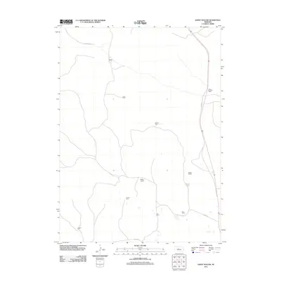
2011 Map of Happy Hollow
USGS Topo · Published 2011About this map
Individual family ranch holdings define the landscape of this Logan County quadrangle in the Nebraska Sandhills. The settlement pattern is characterized by widely dispersed homesteads connected by a sparse network of unpaved roads, such as Paxton Santo Rd and Sturtz Rd. This 2011 survey documents the persistent agricultural footprint of the region, where named locations like Santos Ranch, Christian Ranch, and Beacon Brothers Ranch serve as primary geographical landmarks. Natural features are equally prominent in this cattle-ranching territory, with the titular Happy Hollow and Green Valley providing relief to the terrain. Water sources are rare and vital in this environment, as evidenced by the presence of Brush Lake near the center of the sheet. The map also records the alignment of Old Hwy 83 on the eastern edge, a key corridor for local travel between these remote family operations.
Find a feature on this map
15 named features on this map. Tap any name to fly to it.
Don’t see what you’re looking for? This feature index may not catch every label — zoom into the map to look around manually.
Map Details
Editions of this 2011 Happy Hollow Map
This is the sole edition of this map. No revisions or reprints were ever made.
Other maps of this area

1948 · Thedford
USGS Topo · 1:62,500

1948 · Halsey
USGS Topo · 1:62,500

1949 · Cody Lake
USGS Topo · 1:62,500

1950 · Thedford
USGS Topo · 1:62,500

1950 · Halsey
USGS Topo · 1:62,500

1951 · Cody Lake
USGS Topo · 1:62,500

1951 · Hoagland
USGS Topo · 1:62,500

1954 · North Platte
USGS Topo · 1:250,000

1956 · North Platte
USGS Topo · 1:250,000

1957 · North Platte
USGS Topo · 1:250,000