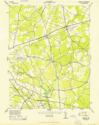
1944 Map of Harbeson
USGS Topo · Published 1944About this map
Agricultural lands and dense woodland patches define this Sussex County landscape during the mid-1940s, organized by the local government districts of the era. The Pennsylvania (Delmarva Division) railroad serves as a central artery for the region, passing through Harbeson and the Saulsbury Switch siding. This transportation corridor connects the small crossroads communities and rural industries that dot the coastal plain, including Morris Mill and the nearby Morris Mill Pond.
Find a feature on this map
50 named features on this map. Tap any name to fly to it.
Don’t see what you’re looking for? This feature index may not catch every label — zoom into the map to look around manually.
Map Details
Editions of this 1944 Harbeson Map
2 editions found
Other maps of this area

1917 · Millsboro
USGS Topo · 1:62,500

1918 · Cedar Creek
USGS Topo · 1:62,500

1918 · Rehoboth
USGS Topo · 1:62,500

1918 · Cape Henlopen
USGS Topo · 1:62,500

1919 · Cedar Creek
USGS Topo · 1:62,500

1937 · Cape Henlopen
USGS Topo · 1:62,500

1938 · Cedar Creek
USGS Topo · 1:62,500

1938 · Millsboro
USGS Topo · 1:62,500

1938 · Rehoboth
USGS Topo · 1:62,500

1943 · Fairmount
USGS Topo · 1:24,000