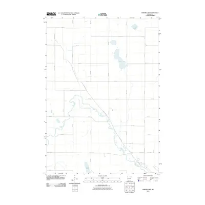
2010 Map of Harder Lake
USGS Topo · Published 2010About this map
The Des Moines River winds through this agricultural portion of Cottonwood County, creating a serpentine corridor of riparian terrain that contrasts with the surrounding rectangular grid of farm roads. Near the center of this 2010 survey, Harder Lake sits amidst a landscape defined by sectional boundaries and long stretches of named thoroughfares like 450th Ave. The mapping of these minor waterways, including Arnolds Lake and the String Lakes to the south, documents the persistent glacial hydrology of the region even as human engineering has formalized the surface with an extensive network of county highways and township roads.
Find a feature on this map
27 named features on this map. Tap any name to fly to it.
Don’t see what you’re looking for? This feature index may not catch every label — zoom into the map to look around manually.
Map Details
Editions of this 2010 Harder Lake Map
This is the sole edition of this map. No revisions or reprints were ever made.
Other maps of this area

1953 · New Ulm
USGS Topo · 1:250,000

1954 · Fairmont
USGS Topo · 1:250,000

1957 · New Ulm
USGS Topo · 1:250,000

1958 · New Ulm
USGS Topo · 1:250,000

1958 · Fairmont
USGS Topo · 1:250,000

1967 · New Ulm
USGS Topo · 1:250,000

1967 · Sanborn SE
USGS Topo · 1:24,000

1967 · Storden
USGS Topo · 1:24,000

1967 · Jeffers
USGS Topo · 1:24,000
1970 · Bingham Lake
USGS Topo · 1:24,000