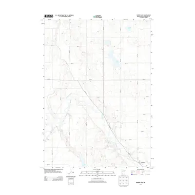
2013 Map of Harder Lake
USGS Topo · Published 2013About this map
Des Moines River meanders through the heart of this Cottonwood County landscape, shaping the local topography as it flows toward the settlement of Windom. The river corridor is flanked by a geometric grid of rural roads, including 420th Ave and 370th St, which define the agricultural land patterns of the early 21st century. To the north and east, several water bodies punctuate the plains, most notably Harder Lake and Arnolds Lake. The diagonal path of Co Hwy-13 cuts across the township grid, serving as a primary connector between the northern lake country and the outskirts of Windom at the southern edge. Along the bottom margin, String Lakes and River Rd mark the transition toward the more developed town site, reflecting the historical dependence on the river valley for both transport and settlement.
Find a feature on this map
26 named features on this map. Tap any name to fly to it.
Don’t see what you’re looking for? This feature index may not catch every label — zoom into the map to look around manually.
Map Details
Editions of this 2013 Harder Lake Map
This is the sole edition of this map. No revisions or reprints were ever made.
Other maps of this area

1953 · New Ulm
USGS Topo · 1:250,000

1954 · Fairmont
USGS Topo · 1:250,000

1957 · New Ulm
USGS Topo · 1:250,000

1958 · New Ulm
USGS Topo · 1:250,000

1958 · Fairmont
USGS Topo · 1:250,000

1967 · New Ulm
USGS Topo · 1:250,000

1967 · Sanborn SE
USGS Topo · 1:24,000

1967 · Storden
USGS Topo · 1:24,000

1967 · Jeffers
USGS Topo · 1:24,000
1970 · Bingham Lake
USGS Topo · 1:24,000