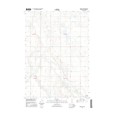
2016 Map of Harder Lake
USGS Topo · Published 2016About this map
The Des Moines River winds diagonally across this Cottonwood County landscape, shaping a valley that transitions from the northern prairie into the outskirts of Windom. In the decade preceding 2016, the area maintained its character as a productive agricultural region defined by a precise grid of county roads and avenues, including Co Rd 50 and 430th Ave. Water features are prominent throughout the northern and southern sections, with Harder Lake and Arnolds Lake sitting among the fields to the north, while the String Lakes are positioned south of the river. The concentration of development near Windom in the lower right corner, including routes like Kalash Rd and 17th St, provides a clear view of the city's northwestern expansion and its relationship to the surrounding river topography.
Find a feature on this map
37 named features on this map. Tap any name to fly to it.
Don’t see what you’re looking for? This feature index may not catch every label — zoom into the map to look around manually.
Map Details
Editions of this 2016 Harder Lake Map
This is the sole edition of this map. No revisions or reprints were ever made.
Other maps of this area

1953 · New Ulm
USGS Topo · 1:250,000

1954 · Fairmont
USGS Topo · 1:250,000

1957 · New Ulm
USGS Topo · 1:250,000

1958 · New Ulm
USGS Topo · 1:250,000

1958 · Fairmont
USGS Topo · 1:250,000

1967 · New Ulm
USGS Topo · 1:250,000

1967 · Sanborn SE
USGS Topo · 1:24,000

1967 · Storden
USGS Topo · 1:24,000

1967 · Jeffers
USGS Topo · 1:24,000
1970 · Bingham Lake
USGS Topo · 1:24,000