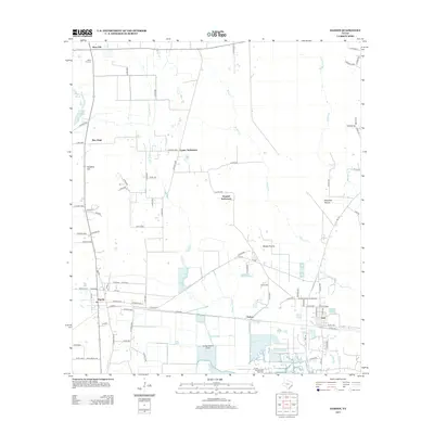
2013 Map of Hardin
USGS Topo · Published 2013About this map
Moss Hill and the Moss Hill Cem anchor the northern reaches of this coastal plain landscape, where scattered settlements and marshes define the local geography. The region's industrial character is clearly marked by the Hull Oil and Gas Field near the community of Hull, suggesting the enduring role of resource extraction in the Liberty County economy. Water dominates the lower elevations, with Walker Marsh and Long Island Cove providing natural drainage into Josie Bayou. A dense network of county roads connects older residential pockets like Tanner Settlement and Dowdel Settlement with the established town center of Hardin. The map reveals a transition from the upland prairies of Batiste Prairie and Mayhaw Prairie toward the more complex hydrologic systems and small reservoirs found as one moves south toward the Gulf coast drainage.
Find a feature on this map
89 named features on this map. Tap any name to fly to it.
Don’t see what you’re looking for? This feature index may not catch every label — zoom into the map to look around manually.
Map Details
Editions of this 2013 Hardin Map
This is the sole edition of this map. No revisions or reprints were ever made.
Other maps of this area

1943 · Liberty
USGS Topo · 1:125,000

1954 · Beaumont
USGS Topo · 1:250,000

1955 · Daisetta
USGS Topo · 1:62,500

1955 · Saratoga
USGS Topo · 1:62,500

1955 · Rayburn
USGS Topo · 1:62,500

1955 · Liberty
USGS Topo · 1:62,500

1957 · Beaumont
USGS Topo · 1:250,000

1984 · Beaumont
USGS Topo · 1:250,000
1984 · Saratoga
USGS Topo · 1:24,000
1984 · Arizona Creek
USGS Topo · 1:24,000