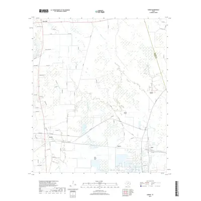
2019 Map of Hardin
USGS Topo · Published 2019About this map
The lowlands of Liberty County unfold across this coastal plain survey, where the convergence of Long Island Cr and Batiste Cr defines the local drainage pattern. The settlement of Hardin serves as a primary hub, situated near the western edge of the map, while Hull and the smaller community of Pedeco anchor the southeastern corner. This area is characterized by its expansive wetland features, including Striplin Marsh and Walker Marsh, alongside open stretches of Batiste Prairie and Mayhaw Prairie. A distinctive landscape feature is Reservoir Number 1, which is situated just north of Long Island Cove. To the north, the elevation rises slightly at Hawkins Hill and Moss Hill, the latter of which contains the Moss Hill Cem. The road network is heavily influenced by the terrain, with local routes like FM 834 E and Co RD 2010 navigating around the numerous bayous and creeks that crisscross the county.
Find a feature on this map
73 named features on this map. Tap any name to fly to it.
Don’t see what you’re looking for? This feature index may not catch every label — zoom into the map to look around manually.
Map Details
Editions of this 2019 Hardin Map
This is the sole edition of this map. No revisions or reprints were ever made.
Other maps of this area

1943 · Liberty
USGS Topo · 1:125,000

1954 · Beaumont
USGS Topo · 1:250,000

1955 · Daisetta
USGS Topo · 1:62,500

1955 · Saratoga
USGS Topo · 1:62,500

1955 · Rayburn
USGS Topo · 1:62,500

1955 · Liberty
USGS Topo · 1:62,500

1957 · Beaumont
USGS Topo · 1:250,000

1984 · Beaumont
USGS Topo · 1:250,000
1984 · Saratoga
USGS Topo · 1:24,000
1984 · Arizona Creek
USGS Topo · 1:24,000