
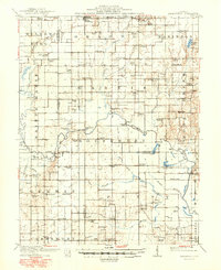
1910 Map of Hardinville
USGS Topo · Published 1910About this map
The Embarrass River meanders through this Illinois landscape during a time of rural growth and early industrial interest. The presence of Oil Center suggests the emerging energy economy of the era, while the Indianapolis Southern railroad provides a vital link to the north through Oblong. The map reveals a dense network of social foundations, featuring numerous family-named and community landmarks like the Mann School, Petty Church, and St Joseph Church.
Find a feature on this map
91 named features on this map. Tap any name to fly to it.
Don’t see what you’re looking for? This feature index may not catch every label — zoom into the map to look around manually.
Map Details
Editions of this 1910 Hardinville Map
2 editions found
Other maps of this area

1911 · Sumner
USGS Topo · 1:62,500

1913 · Sumner
USGS Topo · 1:62,500

1915 · Vincennes
USGS Topo · 1:62,500

1917 · Birds
USGS Topo · 1:62,500

1940 · Greenup
USGS Topo · 1:62,500

1941 · Newton
USGS Topo · 1:62,500

1942 · Birds
USGS Topo · 1:62,500

1943 · Greenup
USGS Topo · 1:62,500

1943 · Newton
USGS Topo · 1:62,500

1944 · Vincennes
USGS Topo · 1:62,500