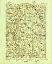
1903 Map of Harford
USGS Topo · Published 1945About this map
The Tioughnioga River corridor serves as a primary artery for industry and transport at the turn of the century, carrying the Delaware Lackawanna and Western railroad through the settlements of Marathon and Killawog. Further west, the Lehigh Valley (Auburn Division) follows the valley floor of the West Branch Owego Creek, connecting Harford and Richford. This mapping of the Southern Tier reflects a landscape defined by sharp elevation changes and high ridges, where agriculture and small hamlets are concentrated in the narrow drainage basins.
Find a feature on this map
52 named features on this map. Tap any name to fly to it.
Don’t see what you’re looking for? This feature index may not catch every label — zoom into the map to look around manually.
Map Details
Editions of this 1903 Harford Map
5 editions found
Other maps of this area

1898 · Moravia
USGS Topo · 1:62,500

1900 · Dryden
USGS Topo · 1:62,500

1901 · Apalachin
USGS Topo · 1:62,500

1902 · Moravia
USGS Topo · 1:62,500

1903 · Cortland
USGS Topo · 1:62,500

1903 · Owego
USGS Topo · 1:62,500

1903 · Harford
USGS Topo · 1:62,500

1904 · Binghamton
USGS Topo · 1:62,500

1904 · Greene
USGS Topo · 1:62,500

1904 · Apalachin
USGS Topo · 1:62,500