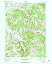
1976 Map of Harford
USGS Topo · Published 1984About this map
The Birthplace of John D Rockefeller sits within this rural landscape where Cortland, Tioga, and Broome Counties meet. The terrain is defined by steep ridges and deep hollows like Babcock Hollow and Quail Hollow, sheltering small agricultural settlements and rural intersections. The Lehigh Valley Railroad runs through the valley floor, connecting the hamlets of Harford and Harford Mills along the East Branch Owego Creek.
Find a feature on this map
36 named features on this map. Tap any name to fly to it.
Don’t see what you’re looking for? This feature index may not catch every label — zoom into the map to look around manually.
Map Details
Editions of this 1976 Harford Map
2 editions found

Other maps of this area

1898 · Moravia
USGS Topo · 1:62,500

1900 · Dryden
USGS Topo · 1:62,500

1902 · Moravia
USGS Topo · 1:62,500

1903 · Cortland
USGS Topo · 1:62,500

1903 · Harford
USGS Topo · 1:62,500

1906 · Catatonk
USGS Topo · 1:125,000

1942 · Groton
USGS Topo · 1:24,000

1943 · Groton
USGS Topo · 1:31,680

1944 · Cortland
USGS Topo · 1:31,680
1944 · Mc Graw
USGS Topo · 1:31,680