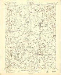
1918 Map of Harrington
USGS Topo · Published 1918About this map
Harrington stands at the crossroads of the P B and W RR and several regional thoroughfares, serving as a primary rail hub for central Delaware just after the First World War. This landscape is defined by its extensive drainage networks, where White Marsh Ditch, Engle Ditch, and Haines Ditch reflect a sophisticated effort to manage the low-lying terrain for agriculture. The map captures the dense settlement pattern of the era, marked by numerous named crossroads such as Hopkins Corners, McNett Corners, and Masters Corners.
Find a feature on this map
99 named features on this map. Tap any name to fly to it.
Don’t see what you’re looking for? This feature index may not catch every label — zoom into the map to look around manually.
Map Details
Editions of this 1918 Harrington Map
4 editions found
Other maps of this area

1899 · Vineland
USGS Topo · 1:125,000

1899 · Dover
USGS Topo · 1:125,000

1905 · Denton
USGS Topo · 1:62,500

1905 · Barclay
USGS Topo · 1:62,500

1905 · Hurlock
USGS Topo · 1:62,500

1906 · Dover
USGS Topo · 1:125,000

1915 · Seaford
USGS Topo · 1:62,500

1917 · Millsboro
USGS Topo · 1:62,500

1918 · Cedar Creek
USGS Topo · 1:62,500

1918 · Harrington
USGS Topo · 1:62,500