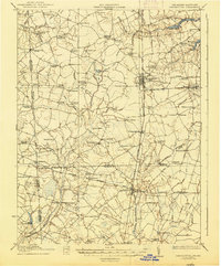
1918 Map of Harrington
USGS Topo · Published 1938About this map
Harrington serves as the central rail hub in this early 20th-century landscape, where the Philadelphia Baltimore and Washington line intersects the local infrastructure of Kent and Sussex counties. The terrain is defined by an intricate network of drainage ditches and branches, such as the White Marsh Ditch and Tantrough Ditch, which supported the agricultural productivity of the Delmarva Peninsula.
Find a feature on this map
92 named features on this map. Tap any name to fly to it.
Don’t see what you’re looking for? This feature index may not catch every label — zoom into the map to look around manually.
Map Details
Editions of this 1918 Harrington Map
4 editions found
Other maps of this area

1899 · Vineland
USGS Topo · 1:125,000

1899 · Dover
USGS Topo · 1:125,000

1905 · Denton
USGS Topo · 1:62,500

1905 · Barclay
USGS Topo · 1:62,500

1905 · Hurlock
USGS Topo · 1:62,500

1906 · Dover
USGS Topo · 1:125,000

1915 · Seaford
USGS Topo · 1:62,500

1917 · Millsboro
USGS Topo · 1:62,500

1918 · Cedar Creek
USGS Topo · 1:62,500

1918 · Harrington
USGS Topo · 1:62,500