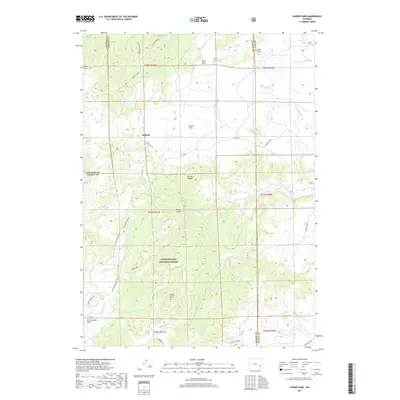
2017 Map of Harris Park
USGS Topo · Published 2017About this map
Medicine Bow National Forest dominates the southern reaches of this Wyoming landscape, where the high elevations of Albany Peak and Rock Mtn look down upon a network of drainage basins. The settlement pattern is defined by small clusters like Binford and Harris Park, situated along a system of rural routes including Harris Park Rd and Co Rd 71. This 2017 survey reveals how the topography dictates local movement, with roads following the natural contours of the land near Elliott Point and threading through gaps between peaks.
Find a feature on this map
39 named features on this map. Tap any name to fly to it.
Don’t see what you’re looking for? This feature index may not catch every label — zoom into the map to look around manually.
Map Details
Editions of this 2017 Harris Park Map
This is the sole edition of this map. No revisions or reprints were ever made.
Other maps of this area

1943 · Esterbrook
USGS Topo · 1:62,500

1945 · Esterbrook
USGS Topo · 1:62,500

1949 · Spring Creek
USGS Topo · 1:24,000

1950 · Spring Creek
USGS Topo · 1:24,000

1950 · Cottonwood Falls
USGS Topo · 1:24,000

1951 · Cottonwood Falls
USGS Topo · 1:24,000

1953 · Johnson Mountain
USGS Topo · 1:24,000

1954 · Torrington
USGS Topo · 1:250,000

1958 · Torrington
USGS Topo · 1:250,000
1968 · Fletcher Park
USGS Topo · 1:24,000